As its name implies, the jet stream is essentially a river of fast-moving air in the atmosphere at about the altitude where airplanes fly. It is typically a few hundred miles across, and jets can indeed save a lot of fuel if they can fly within this air current, generally from west to east.
Jet streams also have significant implications for our weather on the ground, as they more or less steer storm systems that affect the mid-latitudes. That is, they in large part determine whether parts of the United States—which lies almost entirely in the mid-latitudes between the tropics and poles in the Northern Hemisphere—will see stormy or serene weather.
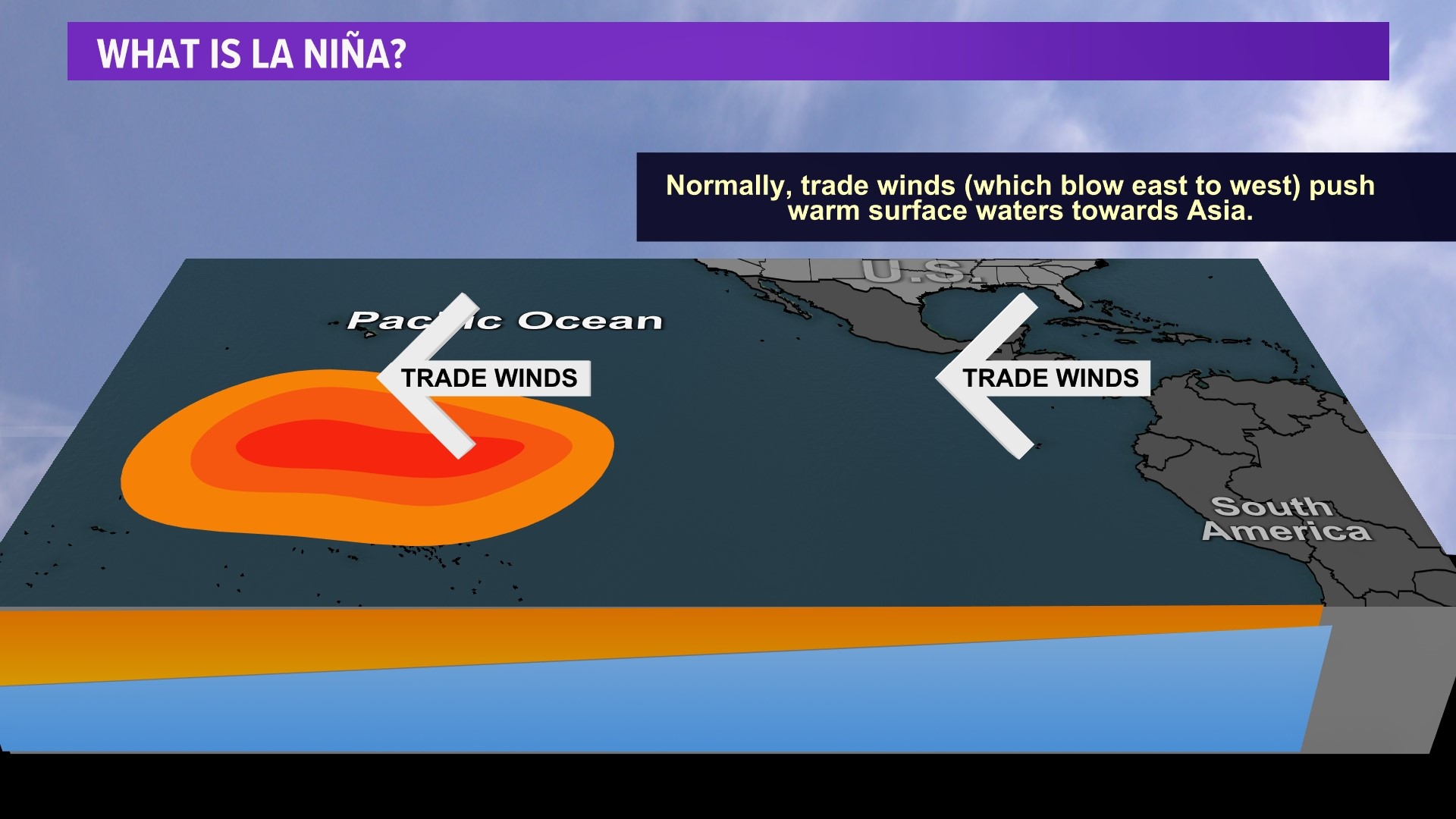
As always with weather, the situation is complex. But one of the more useful signals in a forecaster's arsenal is the El Niño–Southern Oscillation in the tropical Pacific Ocean, which vacillates between warmer sea surface temperatures (El Niño), cooler ones (La Niña), and neutral conditions. This broad pattern has widespread weather implications, including the location of the jet stream.

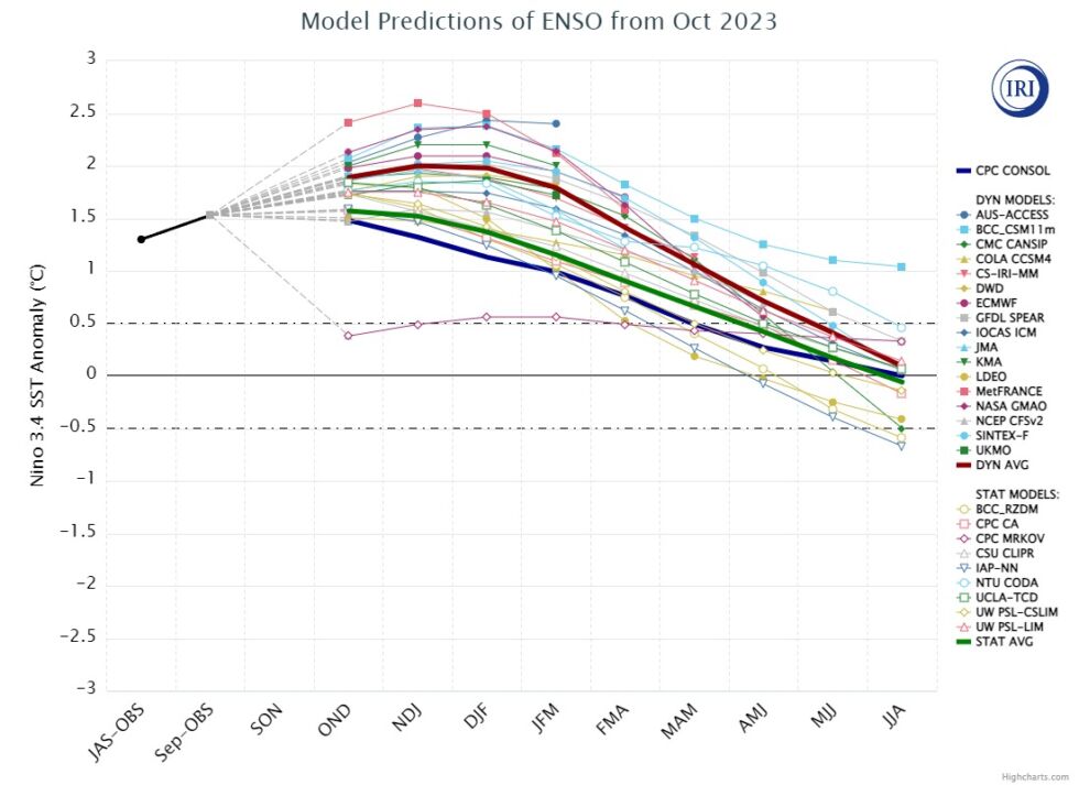
You probably know that we've been in an El Niño pattern since late spring. This is one reason why the summer of 2023 was so incredibly hot, as the addition of El Niño goosed the background warming of climate change after several La Niña years. Forecasters at the National Oceanic and Atmospheric Administration and Columbia University, who specialize in the Southern Oscillation, now predict that El Niño will peak late this fall into the winter months. It will be a fairly strong El Niño, with implications for this winter and—more speculatively—for next summer, which should be hot again.
Winter outlook
When El Niño is present during the winter months, it generally has a pronounced effect on the Pacific jet stream. Instead of being variable in its track, often entering North America near the state of Washington and southern British Columbia, it more consistently tracks into California and Mexico's Baja peninsula. This brings a more southerly storm track.
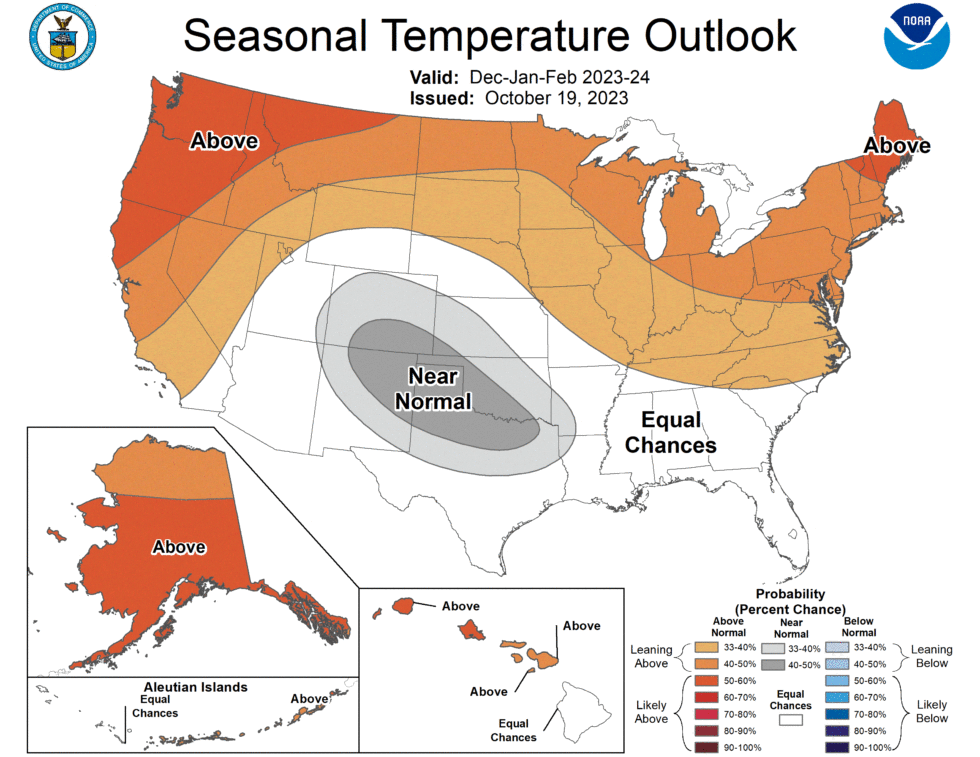
Since this pattern is what we'll see this winter, we can have a reasonably high confidence in a seasonal forecast for the United States. So when NOAA released its official outlook for the coming winter last week, it's no surprise that they're predicting a warmer and mild winter for the northern United States (and southern Canada, although it is not explicitly included in the US government agency's forecast). The southern half of the country should see near-normal conditions.

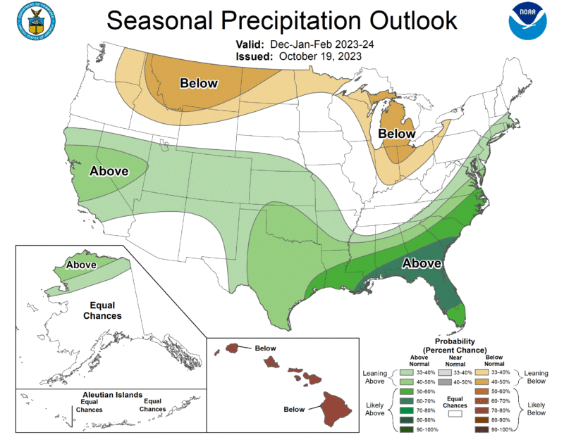
The more interesting change comes in precipitation. Consistent with a more southerly jet stream, the northern tier of the United States should see a fairly dry winter. This may well mean less snow in the Great Lakes region of the country. However, the more southerly part of the country is likely to see an enhanced storm pattern, which generally means more rainfall.
This should be beneficial to parts of New Mexico, Texas, Louisiana, and Mississippi, which are in the throes of an "exceptional drought" after an extremely hot summer in which high pressure dominated and there was relatively little precipitation.
“During late October, heavy precipitation is likely to result in drought improvement for the central US," said Brad Pugh, operational drought lead with NOAA’s Climate Prediction Center. "El Niño with its enhanced precipitation is expected to provide drought relief to the southern US during the next few months."
The bigger picture
These are only broad, background patterns, of course. This does not mean the upper Midwest won't see some snowstorms or seriously cold weather this winter. Texas, you may recall, saw one of its coldest winter storms in the last half century in early 2021, which knocked out power to millions in the state. This very cold weather came amid a La Niña winter, which is supposed to bring milder conditions to the southern United States. So, as always, the utility of seasonal forecasts is relatively low.
The other wild card, of course, is climate change. We saw unprecedentedly hot conditions this summer for much of the world, including the hottest temperatures ever recorded in parts of the Gulf of Mexico and Atlantic Ocean. What this all means for older, established weather patterns, we can't really say. All we can really know is what George R.R. Martin told us decades ago: "Winter is coming."


3175x175(CURRENT).thumb.jpg.b05acc060982b36f5891ba728e6d953c.jpg)
Recommended Comments
Join the conversation
You can post now and register later. If you have an account, sign in now to post with your account.
Note: Your post will require moderator approval before it will be visible.