3175x175(CURRENT).thumb.jpg.b05acc060982b36f5891ba728e6d953c.jpg)
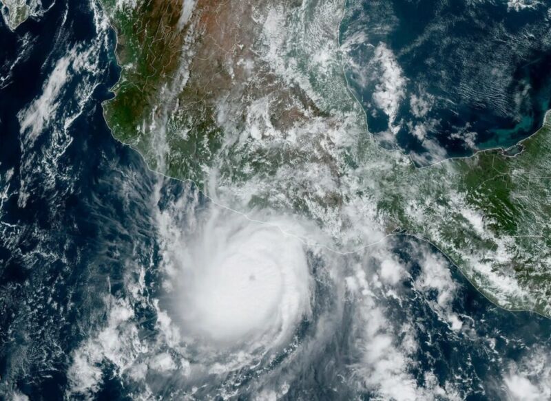
The word "unprecedented" gets tossed around a lot these days, but what happened with Hurricane Otis and its impact on Acapulco on Tuesday were truly without precedent. And it was with only slight precedent anywhere in terms of how quickly it intensified.
Otis was the textbook definition of rapid intensification, going from a 50 mph tropical storm on Monday evening to a 165 mph category 5 hurricane last night. Through about mid-morning on Tuesday, everything was going basically as you'd expect for a modest hurricane with Otis. It may have been tracking toward a category 2 type landfall, or even a category 3 type landfall in the worst case, if you assumed the general rules of rapid intensification in this region. But Otis did not follow the rules.
Much like an onion, there are layers to this story that are important. First, take it from one of the more seasoned NOAA hurricane hunters—this was not what they expected when they flew their mission on Tuesday. Meteorologist Jeremy DeHart wrote on the site formerly known as Twitter, "I have arrived to a storm & been surprised by the intensity, but nothing like this. Expected a marginal hurricane, found a Cat 3! Reminiscent of the stories I've heard about flying into Patricia ('05), in the same part of the world."
And this was before Otis had peaked. The typical satellite-derived intensity values often used to "proxy" intensity of storms that are far away from reconnaissance flights failed in this case to grasp how intense Otis was. In other words, Otis intensified so quickly that it basically outran the ability to measure how intense it actually was.
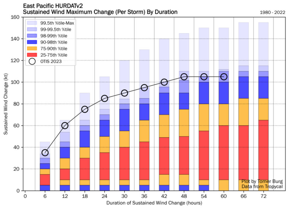
Here was the raw model output for Otis from Tuesday morning. This is what general weather forecasters would use to assess what will happen with a storm's wind forecast. The dashed line is what actually occurred.
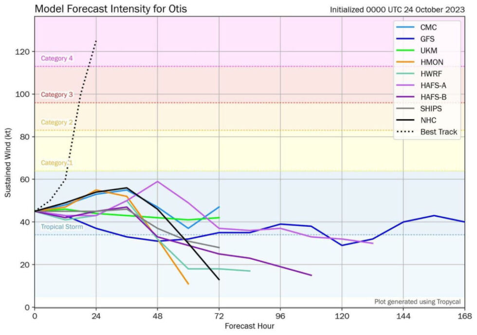
None of the best, most reliable tropical modeling had Otis as a hurricane, let alone a category 5 storm. To put it bluntly, this was an absolutely catastrophic forecasting failure.
By late Tuesday morning, the experts at the National Hurricane Center had it at 90 mph making landfall. This is well above any forecast data, and they concluded in their discussion that it seemed reasonable to potentially see further intensification adjustments upward before landfall. But even in their worst-case scenario, the NHC forecast would have still been off by probably two categories less than 18 hours before landfall. And this was using strong meteorological analysis to bias-correct the models upward, too. To their credit, they had it at 140 mph by the late afternoon advisory.
Interestingly, one of the tools we use to forecast the probability that a storm will rapidly intensify, SHIPS guidance, also failed. Early on Tuesday morning, it showed only about a 2–3x above normal chance that the storm would intensify from a 50 mph tropical storm to a 100–125 mph hurricane. Yes, that is above climatology, but it's not exactly impressive given what we've seen in recent years.
By Tuesday afternoon, those odds had increased to 5–9x above normal. But even this only showed 2x above normal odds that we'd get to 140 mph+. There were finally some hints available by mid to late morning on Tuesday, but nothing that would have offered a meaningful forecast improvement over what the NHC had (which called for 20–30 mph of intensification over 12–24 hours).
How did this happen?
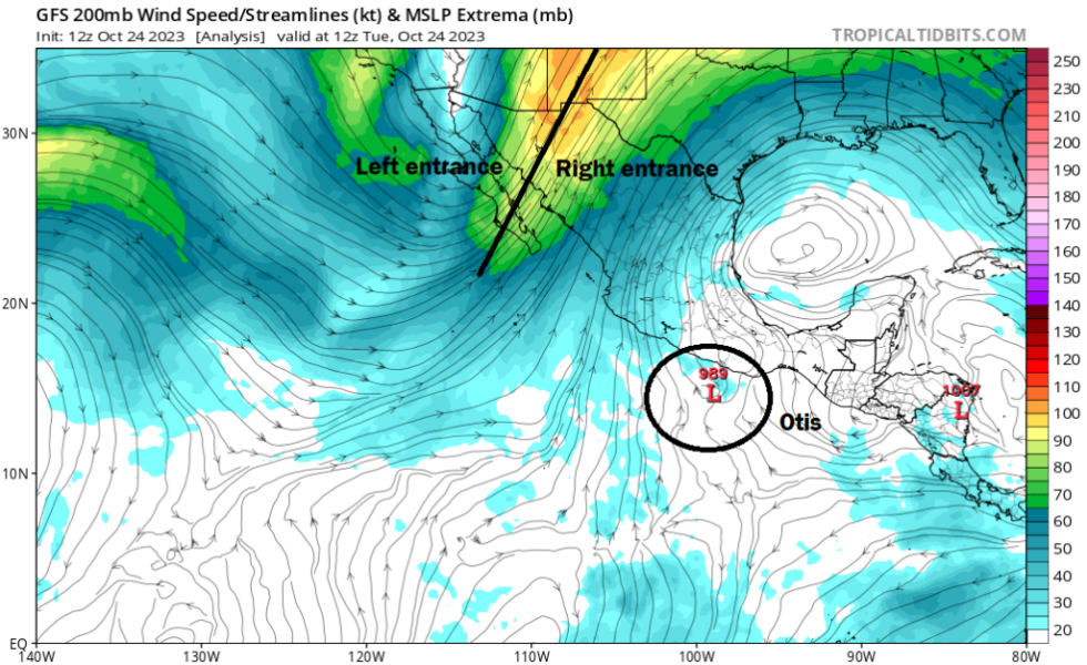
The first question is why Otis did what it did. It was probably a combination of a couple of things. First, Otis was placed ideally in an environment that facilitated constructive wind shear. When we discuss wind shear, it's usually referenced in a negative sense; wind shear inhibits and destroys storms. But in occasional cases, as we've witnessed in the Gulf of Mexico with Ian, Delta, and Zeta, among many other storms in recent years, the wind shear can actually be constructive and help "vent" the system. In this case, Otis was optimally placed in the right entrance region of the jet stream.
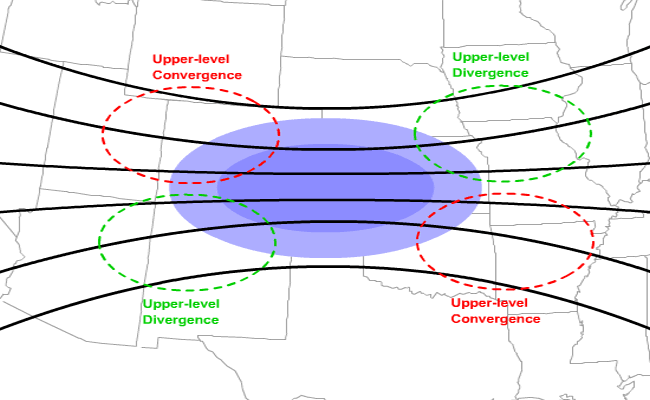
Storms are aided in intensification when placed in the left front or right rear (entrance) of the jet stream. Why? In that portion of the jet stream, the winds aloft diverge, meaning they either move in opposite directions or stronger wind diverges away from weaker wind. Upper-level divergence leads to rising air. Rising air is necessary for storms to form and maintain, and thus surface pressures tend to fall in this region of the jet stream as well.
Recommended Comments
There are no comments to display.
Join the conversation
You can post now and register later. If you have an account, sign in now to post with your account.
Note: Your post will require moderator approval before it will be visible.