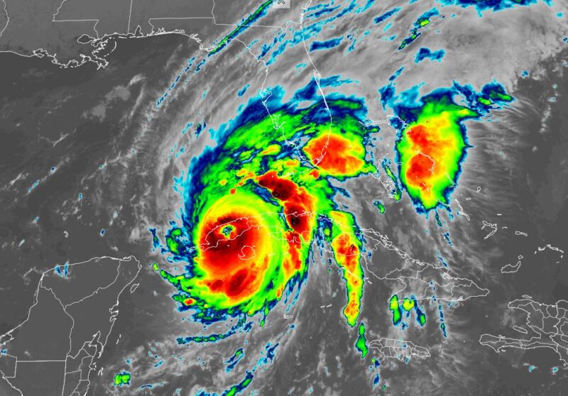
Hurricane Ian continued to intensify on Monday night and reached sustained winds of 125 mph as its center passed across the western edge of Cuba. From there, the storm will move into the southeastern Gulf of Mexico, where very warm water and low wind shear will allow for further intensification.
The hurricane has been moving around the western edge of a high-pressure system, but as Ian approaches the western coast of Florida on Wednesday it will start to run into a trough of low pressure draped across the southeastern United States. The net effect of this will cause Ian to slow down, perhaps only moving a few miles per hour for a couple of days.
All of this is a recipe for disaster for much of the Florida peninsula, but it's difficult to say precisely where, and precisely which effects. Even though landfall is expected to occur in less than two days, there remains considerable uncertainty about where Ian will make landfall along the western Florida coast, and where it will go. This is due, in part, to the breakdown of its steering currents.
Tampa
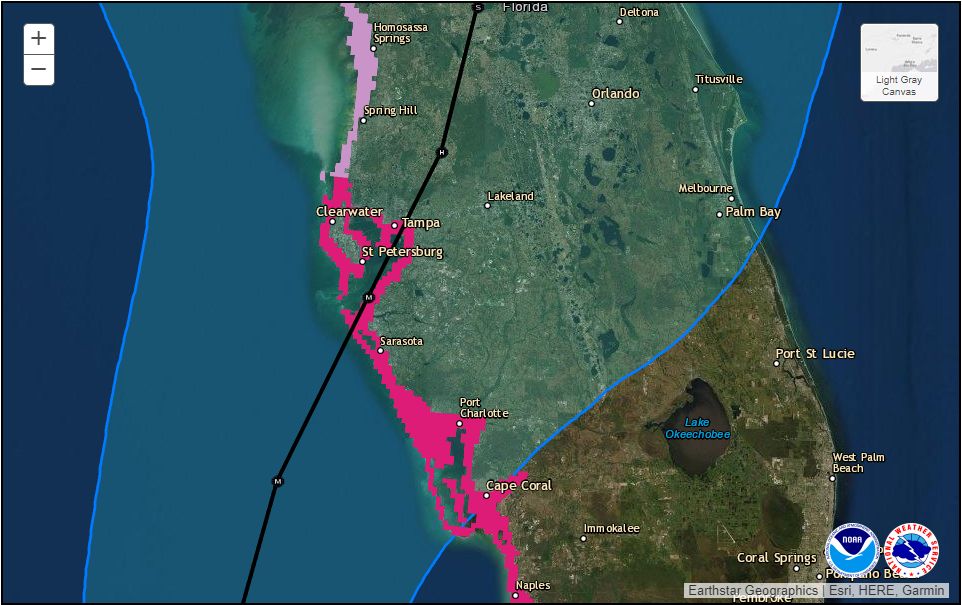
The area most at risk is the densely populated Tampa region, which is built up around a large bay that would serve as a funnel for storm surges. Some risk analyses have found that more than half a million homes in Tampa are vulnerable to surges of water—pushed by the circulation of a hurricane over the ocean—with a replacement cost of $126 billion. About half of the metro area's population lives in homes built at elevations of 10 feet or lower.
In the run-up to Ian's landfall, the Tampa region has received much of the attention due to its large population and the fact that it has not been struck by a major hurricane in more than a century. The region has escaped direct impacts from a powerful hurricane ever since an unnamed hurricane hit the area in late October 1921. The region's population has increased more than 10-fold since then, to about 3 million people.
Were Ian to make landfall on Tampa, or within about 50 to 100 miles to the north, it truly would bring a devastating storm surge to the area, along with major wind damage. These effects, combined with a slow-moving hurricane, would be just about the worst-case scenario storm for Tampa or any populated area.
However, due to the lack of certainty about Ian's track during the next two days, it remains possible that Ian could come ashore south of Tampa. A hurricane's storm surge is always worse to the right of its center, where its counter-clockwise circulation pushes water toward the shore. A landfall even 20 or 30 miles south of Tampa would still be bad, but it would spare Tampa Bay from considerable flood damage.
Rest of Florida
Ian is expected to make landfall along the west or southwest coast of Florida and then track northward across much of the peninsula. Although its winds will be somewhat reduced as the center comes onshore, it will still pack a punch. Inland communities such as Orlando and The Villages, according to the National Hurricane Center, have at least a 1-in-5 chance of experiencing hurricane-force winds.
In addition to the winds, for inland areas of Florida, there is also a serious threat of heavy and prolonged rainfall. Ian's slow movement will exacerbate these rains as part of its large structure remains offshore, drawing moisture to thunderstorms over land.
Although it's not yet possible to have confidence in precisely where the heaviest rains will occur, it seems probable that a swath of 15 to 25 inches of rainfall will cover a significant area of the Florida peninsula as Ian moves inland and drenches the state. This will compound the misery for those whose roofs are damaged by wind or are left without power.

The latest track forecast for Ian also brings the storm center very near, if not directly over, Kenned Space Center and the Cape Canaveral Space Force Station. NASA prudently decided on Monday to roll its massive Space Launch System rocket and Orion spacecraft into the Vehicle Assembly Building for protective cover. While this is likely to cause an approximately six-week delay to the Artemis I mission, that is better than damaging the vehicles.
United Launch Alliance has a mission planned for Friday, September 30, to launch two television broadcast satellites for SES from Cape Canaveral. Expect that to be delayed. NASA, too, is also hoping to launch its next crew mission to the International Space Station as early as October 3. Depending on Ian's effects, including damage to the spaceport and disruption of the lives of those who work there, this Crew-5 launch on SpaceX's Falcon 9 rocket could also be delayed.
On Monday, SpaceX Vice President of Build and Flight Reliability Bill Gerstenmaier said the Crew Dragon spacecraft is mated to the Falcon 9 rocket. For now, however, the vehicles remain safely inside the company's hangar in Florida. "We’re ready to roll out whenever the weather is ready to roll out," Gerstenmaier said during a news conference.


3175x175(CURRENT).thumb.jpg.b05acc060982b36f5891ba728e6d953c.jpg)

Recommended Comments
There are no comments to display.
Join the conversation
You can post now and register later. If you have an account, sign in now to post with your account.
Note: Your post will require moderator approval before it will be visible.