3175x175(CURRENT).thumb.jpg.b05acc060982b36f5891ba728e6d953c.jpg)
Zoom in over rural North Texas for a spacey surprise.
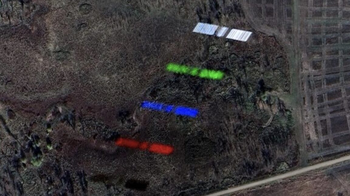
One of SpaceX's Starlink satellites appears five times in this view on Google Earth.
Credit: Google Earth
Dig deep on Google Earth and you'll inevitably find a surprise or two. Maybe you're looking at far-flung islands in the middle of an ocean or checking in on something closer to home.
A few years ago, online sleuths found an image of a B-2 stealth bomber in flight over Missouri. The aircraft is smeared in the image because it was in motion, while the farm fields below appear as crisp as any other view on Google Earth.
There's something else that now appears on Google Earth. Zoom in over rural North Texas, and you'll find a satellite. It appears five times in different colors, each projected over wooded bottomlands in a remote wildlife refuge about 60 miles (100 kilometers) north of Dallas.
Satellites in low-Earth orbit soar up to 40 times higher than a B-2 bomber and travel about 30 times faster. But there are more than 9,300 active satellites currently in orbit, and thousands more space debris objects, compared to 19 operational B-2 bombers in the Air Force's inventory.
Relative velocity
Someone first shared Google Earth's satellite capture last week on Reddit. The identity of the satellite hasn't been confirmed, but its appearance is similar to that of a SpaceX Starlink satellite, specifically a Starlink V2 Mini, with two solar panels spanning some 100 feet (30 meters) end to end. There are more than 7,000 Starlink satellites in space today, more than all other satellite constellations combined, so it wouldn't be surprising that the first Google Earth capture of another spacecraft in orbit would show a Starlink.
Google Earth data indicates that the image was taken on November 30, 2024, by a high-resolution Pleiades observation satellite owned by Airbus. Another Reddit user suggested the satellite could be a Chinese Earth-imaging spacecraft named Ziyuan 3-02, which was flying in the same area as the Pleiades satellite at the time.
Regardless of the identity of the satellite, this image is remarkable for several reasons.
First, despite so many satellites flying in space, it's still rare to see a real picture—not just an artist's illustration—of what one actually looks like in orbit. For example, SpaceX has released photos of Starlink satellites in launch configuration, where dozens of the spacecraft are stacked together to fit inside the payload compartment of the Falcon 9 rocket. But there are fewer well-resolved views of a satellite in its operational environment, with solar arrays extended like the wings of a bird.
This is changing as commercial companies place more and more imaging satellites in orbit. Several companies provide "non-Earth imaging" services by repurposing Earth observation cameras to view other objects in space. These views can reveal information that can be useful in military or corporate espionage.
Secondly, the Google Earth capture offers a tangible depiction of a satellite's speed. An object in low-Earth orbit must travel at more than 17,000 mph (more than 27,000 km per hour) to keep from falling back into the atmosphere.
While the B-2's motion caused it to appear a little smeared in the Google Earth image a few years ago, the satellite's velocity created a different artifact. The satellite appears five times in different colors, which tells us something about how the image was made. Airbus' Pleiades satellites take pictures in multiple spectral bands: blue, green, red, panchromatic, and near-infrared.
At lower left, the black outline of the satellite is the near-infrared capture. Moving up, you can see the satellite in red, blue, and green, followed by the panchromatic, or black-and-white, snapshot with the sharpest resolution. Typically, the Pleiades satellites record these images a split-second apart and combine the colors to generate an accurate representation of what the human eye might see. But this doesn't work so well for a target moving at nearly 5 miles per second.
Hope you enjoyed this news post.
Thank you for appreciating my time and effort posting news every day for many years.
News posts... 2023: 5,800+ | 2024: 5,700+ | 2025 (till end of March): 1,357
RIP Matrix | Farewell my friend 
Recommended Comments
There are no comments to display.
Join the conversation
You can post now and register later. If you have an account, sign in now to post with your account.
Note: Your post will require moderator approval before it will be visible.