I have lived near the Texas coast for two decades and written about hurricanes professionally for nearly as long. When you do that, you think a lot about what would become of your home should the worst happen.
Well, the worst is happening in Southwest Florida today.
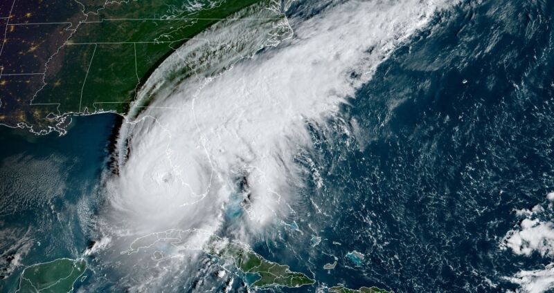
Hurricane Ian has undergone a remarkable period of intensification during the last 24 hours. After crossing the western end of Cuba and knocking that island nation's power grid offline, Ian started to weaken a bit Tuesday following this brief interaction with land. It also underwent an "eyewall replacement cycle," in which the centermost bands of the storm contract and are replaced by a new ring of storms farther out. Often this process temporarily weakens a storm, but Ian was hardly fazed.
Following this cycle, by sunrise on Wednesday morning, Ian was larger and more powerful than ever before, with 155 mph winds. At this intensity, it would become the fifth most powerful hurricane to strike the United States in more than 150 years of records when it slams into the Southwest Florida coast later today, likely near Ft. Myers.
Primary threats
As a forecaster you worry about three primary threats from hurricanes—strong winds, storm surge, and inland rainfall.
Usually a hurricane brings one or two of these threats to a region, but not typically all three. For example, in the Houston region during my lifetime here, we have seen extreme rainfall from Hurricane Harvey, in 2017, and a powerful storm surge from Hurricane Ike in 2008. But Harvey didn't really bring serious wind or surge into the Houston area, and while Ike had some damaging winds, most of the city did not see hurricane-force conditions.
Ian is a monster that will bring all three threats into Southwest Florida with devastating effect.
The National Hurricane Center now forecasts a storm surge of 12 to 16 feet from Englewood to Bonita Beach, Florida. The large wind field associated with Ian will destroy structures along the Western Florida coast and likely knock electricity offline to one-half or possibly two-thirds of the state. Because Ian is moving slowly, and expected to slow further as its steering currents weaken, it will deluge the state. Nearly the entire Florida peninsula is at risk for flash flooding, with a large chunk of the middle of the state, including Tampa, Orlando, Jacksonville, and the Space Coast, at a "high" risk of flash flooding.
Put another way, what doesn't get submerged by massive waves is at risk of being blown down or subsequently flooded by torrential rainfall.
Nightmare fuel
This is not hyperbole. If you live in Houston you probably know that I have a local meteorology website known as Space City Weather. The site's tagline is literally "hype-free forecasts for Houston." I am known as the "no-hype" guy. And let me tell you, Hurricane Ian is the kind of nightmare storm that I worry about most. It is the kind of storm that destroys a community forever, knocks the power out for weeks or, in some locations, months. Beaches are erased. Populations leave and never come back.
There are no silver linings with such weather, but it is true that Ian's track has steadily bent more eastward than expected. As a result the densely populated Tampa Bay region, with more than 3 million people, is now far enough away to escape a catastrophic storm surge. Instead, Ian will push a wall of water into Ft. Myers and Cape Coral areas. This metro area has a population of about 750,000. To the south of this community, where the worst of the surge and winds will occur, lie the Florida Everglades. While pushing so much salt water into this natural environment has its own consequences, fewer people lie in harm's way.
As a forecaster, that doesn't really matter to me. I'm looking at the terrifying, shocking, and yes, breathtaking satellite imagery of Ian and thinking about what might have been had this storm traversed the Gulf of Mexico and struck my community. In my darkest dreams, it's the worst kind of storm I can conjure.
I feel sick.


3175x175(CURRENT).thumb.jpg.b05acc060982b36f5891ba728e6d953c.jpg)


Recommended Comments
There are no comments to display.
Join the conversation
You can post now and register later. If you have an account, sign in now to post with your account.
Note: Your post will require moderator approval before it will be visible.